Don't Come Around Here No More
This blogger site is now defunct.
Please update your links to http://www.modernhiker.com, to continue to see this site in all its WordPress-enabled glory.
Thanks!
This blogger site is now defunct.
Please update your links to http://www.modernhiker.com, to continue to see this site in all its WordPress-enabled glory.
Thanks!
I don't surf.
Hell, I can barely even tolerate the beach. And if I am at one, it better be of the rocky, inhospitable sort, like the coasts of Maine or Big Sur.
But if I did, for some reason, perhaps in the future, decide to take up surfing, I would want to learn while wearing the $460 Headzone Helmet. It's basically a fancy helmet with a waterproof radio, so whoever's teaching me can do so from the comfort of his beachbound Barcalounger.
It also looks ridiculous. But to each his own, I suppose.
Via The Goat.
How many times have you found yourself on the trail in need of a little photo-stabilization device? If you're too cheap to buy a Gorillapod, and you're ok with letting your camera teeter ominously on top of a water bottle, the fifty cent solution over at Instructables might be just what the doctor ordered.
You know, the shady doctor with the laser jet diploma. That guy.
I want an important part of this site to be the trail write-ups I've been doing for the past year over at the old site, except with more technical information and guidance buried in with my rambling observations.
So, after picking up a new GPS, I decided to test it out (and inaugurate the new site) with the Hike That Got Me Hiking - Sandstone Peak.
When I first started hiking here, I'd been doing smaller hikes in the Topanga Canyon area, and eventually I wanted to try something a bit more ... mountainous. The Mishe Mokwa Trail was on the menu, and after that I was hooked.
This trail is challenging without being impossible, solitary without being desolate, and with views, landmarks, and smells that will lodge in your brain and keep calling you back. In other words, it's the perfect hike for the hiker who doesn't know he's a hiker yet.
Does that make sense?
If not, just know that this marks the fourth time I've been back on this trail - far more than any other hike I've been on. I went solo my first time, the second time I took two novice hikers on their first trail, and this is the hike I took my visiting family on to show them the glory of the California wilderness. Everyone finished, in varying stages of exhaustion. Even my mom.
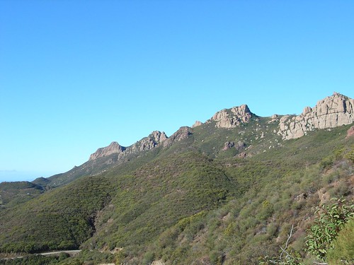
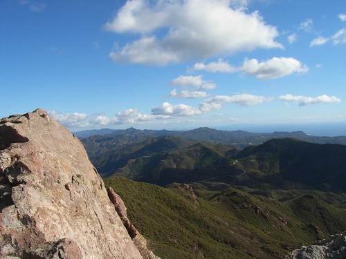
I hadn't been back since August, and all I had to do to get excited again was round those bends on Yerba Buena Road. As soon as I saw that sheer wall of rock against a perfect blue sky, I knew I was home again.
I pulled into the parking lot and was surprised to find only one other car there. I blamed it on the all-weekend rain predictions we'd been hearing since Tuesday, strapped on my gear and headed up.
If you're doing this as a loop trail, the elevation gain is barely noticeable for most of the trip. Unfortunately, the first half a mile is one of those noticeable areas. About 400 feet in under half a mile. But soon you're on the Mishe Mokwa, gently winding around and up. And you've got some great vistas to the east to distract you. Most of the southern parts of the trail are through chaparral, and very open to the sunlight. Soon, though, the vegetation starts to surround you - various brushes and mosses, and unbelievably fragrant California laurel and junipers. There were several times I just had to stop and smell as much as I could.
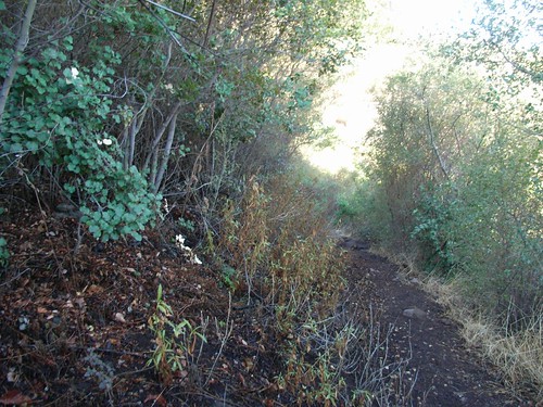 It really is quite nice, but the extra shade does make the northern parts of the trail significantly cooler. I had my newly-traditional winter layers with me, so all was good.
Soon, I got my first sight of Balanced Rock, the impossibly large, teetering boulder that's straight out of an old Road Runner cartoon. No picture does it justice. The upper rock is the size of a freakin' house. And it's just sitting there, waiting for the Big One so it can run rampaging into the nearest canyon.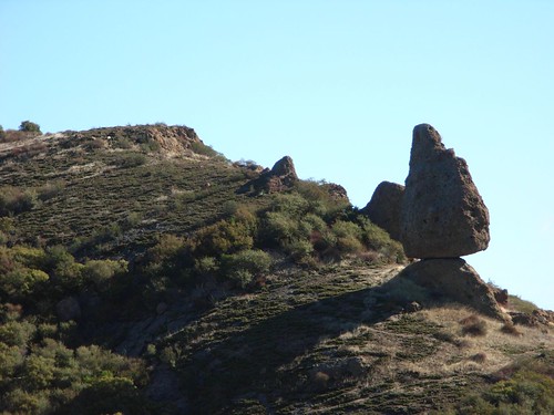 You can hop off the Mishe Mokwa Trail just north of Split Rock for a short bushwhacking adventure to get to Balanced Rock and some good climbing walls nearby. You can also scramble down into the canyon below (which has a nice stream running in the spring), but the last time I saw someone come out of that canyon, 60% of their body was covered in poison oak. FYI.
I bypassed the Rock and continued on the Mishe Mokwa, passing countless windswept rock formations and a few dry stream beds.
Soon, I had my first view of other hikers - three tiny figures on the distant ridge of Boney Mountain: I still haven't hit up that particular peak, yet. On the list, but not for today.
Instead, I took a short spur off the Mishe Mokwa to the Tri-Peaks.
The Tri-Peaks Trail was significantly more rugged and overgrown than the Mishe Mokwa or Backbone Trails. Whereas most of the trail up to this point is fairly wide, mostly level footpaths, this was overgrown, washed out, and in need of a bit of maintenance. Unless, of course, you like that sort of thing. Which I do.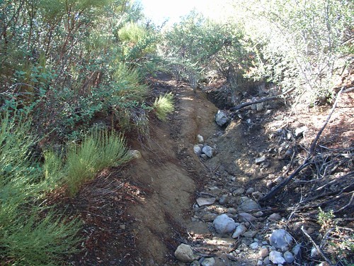 I'm used to tougher trails than this, and relished the chance to get my legs tore up by some Spanish Bayonets. And, as luck would have it, the trail fulfilled that request for me.
Soon, the trail climbed out of the brush and onto the rocky south face of the Tri-Peaks ... where it pretty quickly spiraled off into several false trails. If you look a bit northeast of the face, you'll see a small steel pole sticking up out of the mountain. It's a USGS marker, and the way to the proper trail. A little boulder scrambling later, and you'll be face to face with the Tri-Peaks.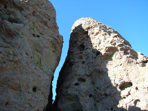 The Peaks themselves are basically three large boulders, surveying everything in sight - from Thousand Oaks, Camarillo and beyond to the Channel Islands and Malibu. They're pretty close together, and their porous surface makes for great climbing if you're in the mood to play King of the Mountain. Or you can just relax on the nearby ledge and soak in some sun and views of distant Sandstone Peak. Way better dealing with the crowds at the beach.
 Or you can do both, like I did.
While I was hanging out on the ledge, the three Boney Mountain Hikers came huffing around the bend. They had started up by the Boney Mountain Cultural Center in Thousand Oaks earlier in the day, and told me about the backcountry route from the mountain to the Tri-Peaks. In turn, I tried to get them to put in the extra miles to hit up Sandstone, but they were looking pretty tired. And so, I turned and left them as I headed back to the trail.
Stopping once to look back at the peaks, for good measure: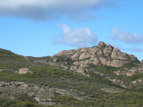 Soon I was back on the Mishe Mokwa, which quickly met up with the wider, more heavily traveled Backbone Trail. The Backbone runs almost 65 miles along ridge of the Santa Monica Mountains, from Will Rogers State Park in Santa Monica to Point Mugu. (link to PDF map and info) You're not supposed to have mountain bikes on the section of the trail near Sandstone Peak, but the trail is wide and riddled with bike tracks. So just keep your eyes open for 'em.
The trail here is exceptional and - in my opinion - far more rewarding if you take 'the long way' on the Mishe Mokwa to get to it. The trail hugs a ridge that drops sharply off below it, opening wide vistas in every direction. There is a short off-trail to Inspiration Point, a small memorial to a Boy Scout, perched on an exposed ledge. There's also some more nice opportunities for climbing along the way, although that first step is a bit too steep for my tastes.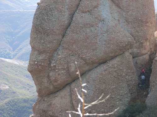 About three quarters of a mile from Inspiration Point, there's a small sign pointing off the trail and into the forest toward Sandstone Peak. This is the sharpest elevation gain of the entire trail, with some portions undefined and on sheer rock face. Don't feel bad about using your hands.
But also don't feel afraid of doing it. It's a challenge, but it's completely doable. Today, I watched a dad shepherd his two small daughters up the mountain with very little trouble. As I was the only other person in sight, the youngest daughter waved at me from above, yelling "Hello, hiker!"
Adorable.
Seriously, if a four year old can do it, you can, too. And when you get to the top, it will be worth it, as miles and miles of southern California mountains and coastline unfurl before you, beneath the watchful eyes of Mr. W. Herbert Allen.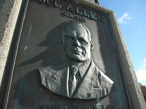
 After that, it's just another short scramble down to the trail. There's a very unofficial dirt path directly north of the Peak that will get you back to the Backbone Trail. It's also very steep and full of very loose rocks. I crab-walked down the last portion, just for kicks. And also, necessity.
And then it's 1.2 miles back to the trailhead, and it's all glorious downhill. I usually do a bit of trail-running here, and today was no exception. But I did stop to take a look at this intricate cairn someone had left before me: I love seeing those things on the trail.
Oh, and the parking lot was completely full when I got back. Lazy Sunday hikers...
The Basics:
For my money, one of the premiere Southern California Trails. A wide variety of landscapes, relatively easy elevation gain, and ample opportunities to explore side-trails.
- Distance: 7.16 miles round trip (6.16 without Tri-Peaks)
- Elevation Gain: 1730 ft (1400 without Tri-Peaks)
- Time: 3 Hours, at a good pace.
- Trail Condition: Very good, and very easy to follow. If you branch off the Backbone or Mishe Mokwa Trails, however, you might need to brush up your navigating skills. Or at least keep your eyes peeled.
- How to Get There: From the PCH, take Yerba Buena Road (right near the border of Los Angeles and Ventura Counties) past the Circle X Ranch. A dirt parking lot is on your left after rounding a bend.
The Notables:
- Sandstone Peak is the highest point in the Santa Monica Mountains.
- Views from Santa Barbara to Santa Catalina Island, inland to the San Gabriels on a clear day.
Extending Your Stay:
- Hikes to Balanced Rock, Exchange Peak and Boney Mountain are easy to add-on to this one. If you know where you're going, you can easily head off-trail to do some exploring of your own. A bit down Yerba Buena Road, you can also visit the Circle X Ranch's Grotto Trail.
As always, more pictures up on Flickr. And check this out! We're now GPS enabled!
Below is a Google Earth window with my trail and waypoints. If you click on the green logo, you'll get more details and be able to download my GPX file and snag this map if you're interested in the trail. You'll also get my warnings about where the nasty Spanish Bayonets are.
If you download it, let me know. I'm still kind of figuring this stuff out, and I'd like to be made aware when stuff's not working right.
If you're like me, one of the reasons you go hiking is to try to capture some awe-inspiring digital photos of your experience. Grand vistas, sweeping mountain ranges, and ... bugs?
The Digital Photography School has a great write-up on macro photography for digital cameras up right now. For those not in the know, macro is the art of eschewing the traditional mountaintop shots for super close ups of dirt, pebbles, insects, and anything else the passing hikers' eye would normally miss.
What's nice about this guide is that it's for the simple, cheap, point-and-shooters that most amateur Ansel Adams' take on the trail with 'em. I mean, I wouldn't mind having a nice SLR, but I'm a bit adverse to their bulkiness. And, you know, their price.
Personally, I use a Ricoh Caplio R5 I picked up when I was in Japan this year (full review forthcoming), and it's got a fairly robust built-in macro mode. Helpful for when you want to make a swarm of ladybugs like this: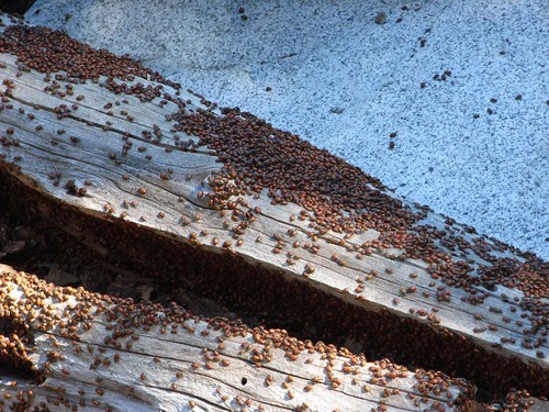
... a bit more personal. Like this: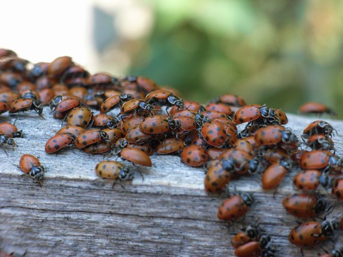
tipped off by Hiking Ideas.
'Ultralight' is the big buzzword among hikers and campers, and for good reason. As soon as you get that backpack strapped to your body, you immediately start wishing you had lighter versions of everything you own.
So what do you do if you want to end your day at camp damaging a few brain cells with the wonderful liquid known as alcohol, but you don't want to deal with the additional liquid weight?
The fine folks at Hiking Ideas have some interesting ideas involving Crystal Light, as well as a low-weight, high-gin recipe for a packable nip. And if, like me, you have a little trouble falling asleep in camp, this sounds like it would do the trick but good.
From one of this week's Writers' Almanacs:
“I turn for solace to rivers, rain, trees, birds, lakes, animals. If things are terrible beyond conception and I walk for 25 miles in the forest, they seem to go away for a while.”
- Jim Harrison, author.


